 Research Team
M Alberti, J Hepinstall, M Marsik, S Coe, R Weeks, and Y Jang,
Problem Definition
A major challenge in modeling the relationships between human and natural processes in coupled human-natural systems is in representing explicitly the human and biophysical agents at a level of disaggregation that allows exploration of the mechanisms linking patterns to processes. Traditional land-use land-cover (LULC) change models are based on average characteristics of the population, households, and businesses as a whole and fail to capture the fine-scale interactions between the many agents and drivers of LULC change. Many conceptualizations of LULC change are based on simple linear assumptions; e.g., people behave uniformly and land-use decisions are governed by land rent and demographic pressures. These aggregation and equilibrium conceptualizations also assume no relevant spatial and temporal dynamics . In reality, the dynamics are often non-linear across time and space, and have intrinsic feedbacks, contagions, and thresholds.
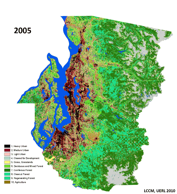
The Land Cover Change Model
As part of our Biocomplexity Projects I and II we have developed a high-resolution land-cover change model (LCCM 1.0(3)) and integrated it with the UrbanSim(4) model . The LCCM is a spatially explicit model that predicts the transition of site-based transitions using time series data of land cover and a rich geospatial data set(2). UrbanSim is a microsimulation model of household location choices which predicts changes over time in the spatial distribution of households, jobs, and real estate quantities, types, and prices. LCCM use inputs from UrbanSim among other input variables and explicitly models the interactions between land use and land cover change and environmental variables through time and space, and dynamic changes resulting from these interactions(5).
The LCCM approach
LCCM is based on a set of spatially explicit multinomial logit models of site-based landcover transitions. The land-cover transition probability of a 30-m cell is a function of the interaction between the current land cover of the cell, its spatial context, and the spatial contagion of development. The model incorporates the spatial context of a 30-m cell by assigning to the cell the landscape composition and configuration of a 150-m window centered on that 30-m cell and determining the distance of the cell from recent and predicted development transitions. Monte Carlo simulation is used to determine if a pixel will transition or remain in its current state. The equations for transition probabilities are estimated empirically as a function of a set of independent variables comparing land-cover data at different points in time (presently for 1991, 1995 and 1999 in Puget Sound). Results from the implementation of the model in the Central Puget Sound region show strong predictive abilities when validated with independent LULC datasets(3).
LCCM and Ecological Functions
The implementation of a high-resolution spatial grid allows us to estimate changes in landscape metrics. In landscape ecology these metrics are good predictors of the ecosystem ability to support important ecosystem functions(6). We use a set of landscape metrics derived from information theory to model the effect of the complex spatial pattern of land use and cover on human and ecological processes. These metrics characterize the composition (e.g. diversity, dominance etc.), spatial configuration (e.g. density, size, shape, edge, connectivity, fractal dimension) and spatial neighborhood (e.g. heterogeneity and contagion) of the landscape.
Integration of LCCM and UrbanSim
UrbanSim has been initially linked to the LCCM, providing location demand outputs as a variable to compute the probability of land cover transition, but there is currently no feedback from LCCM back to UrbanSim. Current configurations of UrbanSim models consider location, land value, land use, and a limited set of land cover descriptors as inputs or constraints on land (re)development. We propose to “close the loop” between the LCCM and UrbanSim. Feedbacks from the LCCM about parcel land cover, as well as contextual land cover metrics representing composition, configuration, and spatial neighborhood could make UrbanSim predictions more robust. This version of the LCCM used an earlier, grid-cell based version of UrbanSim, and the current project would upgrade the LCCM to work with UrbanSim at a parcel level of detail to achieve more behavioral realism. The new location demand outputs from UrbanSim could then influence predictions for the LCCM. Adding spatial configuration and neighborhood effects of both parcels and patches also provides additional realism to the urban and land cover models. Increasing evidence shows that these patterns influence human preference and wellbeing(7), so spatial metrics will be used to model the effects of land use and cover patterns and ecosystem change on UrbanSim agent decisions.
Impact model to capture the effects of land cover change on bird populations
The biological diversity component of this project focuses on understanding colonization and extinction of birds in an urbanizing landscape, and developing models of changes in bird species composition and relative abundance in response to forest loss. We can then generalize and test theory, and suggest general planning and management considerations for those interested in maintaining biological diversity in urbanizing landscapes. Our research on biological responses to land cover change has focused primarily on birds with some additional work on plants and small mammals. Our study sites included139 landscapes (each 1km squared): 115 single-family residential sites, 14 commercial/industrial sites, and 10 forested sites with minimal development.
Effects of mid-twenty-first century climate and land cover change on the hydrology of the Puget Sound basin, Washington
 Effects of mid-twenty-first century climate and land cover change on the hydrology of the Puget Sound basin, Washington
The distributed hydrology–soil–vegetation model (DHSVM) was used to study the potential impacts of projected future land cover and climate change on the hydrology of the Puget Sound basin, Washington, in the mid-twenty-first century. A 60-year climate model output, archived for the Intergovernmental Panel on Climate Change (IPCC) Fourth Assessment Report (AR4), was statistically downscaled and used as input to DHSVM. From the DHSVM output, we extracted multi-decadal averages of seasonal streamflow, annual maximum flow, snow water equivalent (SWE), and evapotranspiration centered around 2030 and 2050. Future land cover was represented by a 2027 projection, which was extended to 2050, and DHSVM was run (with current climate) for these future land cover projections. In general, the climate change signal alone on sub-basin streamflow was evidenced primarily through changes in the timing of winter and spring runoff, and slight increases in the annual runoff. Runoff changes in the uplands were attributable both to climate (increased winter precipitation, less snow) and land cover change (mostly reduced vegetation maturity). The most climatically sensitive parts of the uplands were in areas where the current winter precipitation is in the rain–snow transition zone. Changes in land cover were generally more important than climate change in the lowlands, where a substantial change to more urbanized land use and increased runoff was predicted. Both the annual total and seasonal distribution of freshwater flux to Puget Sound are more sensitive to climate change impacts than to land cover change, primarily because most of the runoff originates in the uplands. Both climate and land cover change slightly increase the annual freshwater flux to Puget Sound. Changes in the seasonal distribution of freshwater flux are mostly related to climate change, and consist of double-digit increases in winter flows and decreases in summer and fall flows.
[project_list page=”1157″]