Summer 2009 Carbon Field Study
During the summer of 2009, the UERL will initiate a field study to understand the long- and short-term carbon consequences of urbanization and different patterns of urban development. The results of this project will directly and immediately inform the Seattle, King County, and Washington state carbon policies.
In our study we will establish and monitor a suite of ground-based observational plots across the urban-to-rural gradients in the Seattle area. We will estimate the carbon stocks and fluxes in live and dead woody plants in 150 observational plots, and then relate the results to landscape development patterns to assess how fragmentation and urbanization processes affect carbon dynamics within the urbanizing Seattle region.
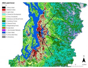
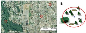
The plots will be distributed across 3 transects radiating from the central Seattle urban core and capturing an urban-to-rural gradient (Figures 1 and 2). Our vegetation measurements will focus on the aboveground and carbon cycle relevant components (plants with a diameter greater than 5-cm, soils, and dead woody debris). Vegetation carbon stocks will be quantified in all plots through biometric methods using plant diameter measurements and allometric equations to estimate carbon stocks in the live and dead carbon pools. Repeated plot surveys will allow for estimates of growth, recruitment, mortality, and decompositional fluxes. Soil carbon stocks, soil carbon-to-nitrogen ratios, and leaf litter depth will be estimated in all plots to test hypotheses about the underlying drivers of changes in the carbon cycle with patterns of development and intensity of urbanization. In addition to biological components, we will carry out a systematic field inventory of key abiotic variables , including assessment of all structural features, the main surface-cover types, and the proportion of impervious surface.

read more:
related publications:
Hutyra, L.R., Yoon, B., Hepinstall-Cymerman, J., and M. Alberti. 2011. Carbon consequences of land cover change and expansion of urban lands: A case study in the Seattle metropolitan region. Landscape and Urban Planning. 103: 83-93.
Hutyra, L.R., Yoon, B., and M. Alberti. 2011. Terrestrial carbon stocks across a gradient of urbanization: A study of the Seattle, WA region.Global Change Biology. 17 (2): 783 – 787.
Investigators: Hutyra, Yoon and Alberti
Research background: Carbon and Urbanization