Previous studies examining impacts of watershed urbanization on coastal ecosystems have identified both sewers and septics as leading stressors. This research examines patterns of alternative wastewater infrastructures in watersheds across seven counties of the Puget Sound. This study incorporates a landscape scale approach to examine sewage disposal types (sewer and onsite septic systems) in coastal sub-basins across a gradient of urbanization from urban to rural and ex-urban areas. Findings from the study show that patterns of wastewater infrastructure represent a complex arrangement of residences on septic and sewer systems particularly in suburban watersheds. This study points to the trade-offs associated with wastewater infrastructure decisions and patterns of urban development, and the implications for coastal ecosystem services.
Description of wastewater infrastructure geodatabase
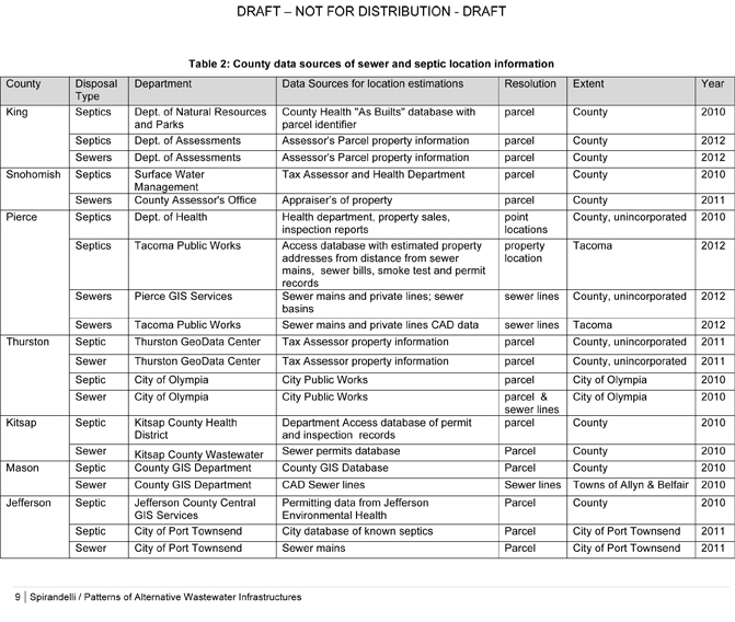
Data was collected on estimated and known locations of parcels with onsite septic systems and parcels hooked up to a centralized sewer system (Table 2). The data originated from numerous county and city agencies including departments of health, tax assessors, public works and city service departments. Most data on estimated parcels on septic systems originated from local health department permitting records or tax assessor’s offices. Data on known parcels hooked up to a sewer system originated from either property assessments by local tax assessor offices or from CAD drawings by local public works departments. The resolution of the data ranged from point address locations, sewer line locations to parcel level. To generate a map of estimated parcels on either a septic system or sewer system, all data was converted to parcel polygon maps where estimated locations were geo-mapped using ESRI’s ArcGIS 9.3 software and associated with the tax assessor’s parcel information using a common parcel Id number. Data with address or point locations were intersected with parcel polygon data. Data with sewer line information was buffered by 50 feet and intersected with all parcels except with ‘Undeveloped’ parcel land uses. Data received from several sources was used to triangulate and estimate locations. All estimated locations were spatially joined with the Washington State Parcel Database and associated with land use information.